|
|
full country name |
|
Republic of Peru |
| capital |
|
Lima |
| population |
|
26.1 million (as of 2001) |
| surface area |
|
1285200 sq km |
| currency |
|
nuevo sol (S/) |
| exchange rate |
|
US$ 1 = S/ 3.50 (as of August 2004) |
| language |
|
Spanish, Quechua |
| main religion |
|
90% Roman Catholic |
| Internet users |
|
1.5% (as of 2000) |
|
| El menú peruano |
| The menú, a Peruvian institution, is a multi-course, set meal offered at many restaurants mainly for lunch and sometimes for supper. It is always good value, costing as little as 30-50% of à la carte ... (more) |
|
| Bon appétit |
| From Thailand, I expected it. From India, I knew it. From Japan, I was anticipating it. I, however, did not have the slightest idea that the food in Peru was going to be so excellent. This may not be true for ... (more) |
|
| Thieves & Scams: 1 kN/gM: 3 |
| Puno. - Five weeks ago, kN and gM came across their first fake one soles coin in Arequipa when trying to pay for Internet time. Having money rejected was perplexing in the context of all their travels ... (more) |
|
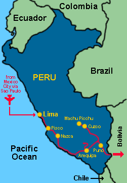
We arrived in Peru on June 30th, 2004, tired out by our strenuous week-long journey from Brisbane to Lima the long way via Singapore, Seoul, Canada, Mexico City, and São Paulo. After spending a longer than anticipated seven weeks in Peru, we crossed into Bolivia at the border near Lake Titicaca on August 20th, 2004.
We walked (security-consciously) around the center of Lima - the pedestrian zone close to Plaza de Armas, the Monasterio de San Francisco, La Catedral, the Museo de la Inquisición, and the Iglesia de La Merced. At the Museo de la Nación in San Borja, we got a taste of Peru's ancient cultures. Most of the time, however, we stayed in the relatively pleasant suburb of Miraflores.
On day six, we headed south, stopping at Pisco where we watched sea lions, penguins, pelicans, and many more birds at the Islas Ballestas. Back on the mainland, the Reserva Nacional de Paracas protects colorful sand dunes and coastal scenery. One hour further south, towering sand dunes completely surround the scenic oasis town of Huacachina, and an excellent museum showcases Paracas, Nazca, and Inca culture in nearby Ica.
Another two hours further south, Nazca is home to probably the most mysterious archaeological heritage of Peru: the Nazca Lines. Consisting of lines, geoglyphs, animal figures, and plant figures, the Nazca Lines were drawn some 1400 to 2900 years ago on the desert floor by removing surface rocks to expose the lighter soil below. Their dimension is so great that they only become visible from the air. One is likely to see many photos of the Nazca Lines before even arriving in Nazca - almost all museums have them. Flying over the Nazca Lines in a four-seater propeller plane, however, is absolutely necessary to grasp the sheer size of the Nasza Lines and put them into the right perspective. Not far from Nazca, the excavation site at the ancient cemetery of Chauchilla displays mummies.
From Nazca, we took a night bus to Arequipa, a city we enjoyed for nine days. First, it boasts an attractive colonial center and fine climate. At 2300m, the days are warm and the nights not too cold. Second, the city has plenty of excellent choices for typical Peruvian, Arequipeño, and international foods. Third, Group C of this year's Copa América soccer tournament was based in Arequipa. We caught games with Brazil, Paraguay, Costa Rica, and Chile in a stadium in a suburb. The stadium was quite small but full of atmosphere, the soccer field scenically being overlooked by the snowcapped peaks of 6075m Chachani and 5822m El Misti.
Fourth, Arequipa is a convenient base from which to visit Cañón del Colca. On our 2-day/1-night bus tour of the canyon, we saw vicuñas, llamas, and alpacas (three of the four members of the South American camelid family) in the Reserva Nacional Aguada Blanca y Salinas. We passed through typical altiplano landscape while the volcanoes of Chachani and El Misti soared to the sky on the horizon. To get to the rim of the canyon, we crossed a pass at 4900m. We experienced mild altitude sickness, even though we had many cups of maté de coca (coca leaf tea) which supposedly helps with acclimatization. In the evening, we relaxed at hot springs while gazing at the night sky. Early in the morning of the second day, we ventured along the rim of the canyon to the Cruz del Cóndor where we were lucky to see as many as nine condors fly elegantly at one time on the winds rising up from the canyon.
|
  |
|
|
   |
| Arequipa's colonial heritage / © gM |
|
  |
|
  |
| Peru's crown jewel: the truly fascinating Machu Picchu / © gM |
|
Fifth, the Museo Santuarios Andinos is world-class. It focuses solely on the well-preserved ice mummy (literally!) Juanita, a girl sacrificed by the Inca at the summit of 6388m high Ampato more than 500 years ago. Furthermore, the huge, colorful Monasterio Santa Catalina is worthy of a visit of many hours, and the library at the Monasterio de la Recoleta includes impressive, 500-year old books. We also witnessed a peaceful paro nacional (nationwide strike), and a parade through the center of Arequipa in honor of the 177th anniversary of a college. From Arequipa, we took yet another night bus to Cuzco - a bus trip full of surprises: each passenger's face was captured on video camera after boarding the bus (security feature?!), we were served dinner, and we played bingo for a free return ticket.
From Cuzco, we travelled by bus and train to Aguas Calientes, our base for visits to the world famous Inca ruins of Machu Picchu. Machu Picchu was as fascinating as we had expected it to be. It is its location, perched on a steep hill and surrounded by towering mountains, which leaves a lasting impression on any visitor. With each fog patch moving over the ruins and each new position of the sun, the ruins never quite look the same as they did a few minutes earlier. Over three days, we went to as many vantage points as we could to experience as many different views of Machu Picchu as possible: from the Hut of the Caretaker of the Funerary Rock (the classic photo view), from Intipunku (Sun Gate, entrance point of the Inca Trail), from Putucusi (the mountain opposite Machu Picchu), from Huayna Picchu (the steep mountain to the right of the ruins), and from the path to Puente Inka (Inca Drawbridge).
Machu Picchu does not boast any intricate carvings or paintings similar to those in Angkor (Cambodia) or Bagan (Myanmar). The Inca's craftship with regard to their masonry is measured by the Inca's ability to tightly fit together heavy blocks of stone and by simple carvings of condors, llamas, and pumas. The enormous silver and gold treasures which more accurately portray the sophistication achieved by the Inca - anything valuable actually - have long been looted by the Spanish conquistadores. What is left can only be seen in museums, e.g. in Lima or Cuzco. It is solely up to the visitor to imagine the splendor of times past.
|
  |
|
|
  |
| Cuzco at night / © gM |
|
  |
| Glyptodon dinosaur and Salinas de Maras / © gM |
|
Back in Cuzco, we explored ruins close to the city and in the Sacred Valley. The degree of excitement these ruins inspired in us after having been to Machu Picchu spans a wide range from high (Pisac, Ollantaytambo, Sacsayhuamán) to okay (Moray, Tipón) to so-so (Tambo Machay, Puca Pucara, Qenko, and Chinchero). Pikillacta and Rumicolca were okay ruins, but featured an amazing museum with one single exhibit: the complete skeleton and armor of a Glyptodon dinosaur, a huge armadillo which lived in South America during the Ice Ages. Not ruins but a real treat, the Salinas de Maras consist of thousands of salt pans located on the southern slope of a small valley near Urubamba. This site has been used for salt extraction since Inca times and is still in use today.
Included in the ticket for the ruins are a number of museums in Cuzco which are all at the most so-so. The Museo de Arte Popular focuses on nacimientos (nativity scenes), the Museo Histórico Regional has the same interesting Inca tools over and over, whereas the Museo de Arte del Monasterio de Santa Catalina, the Museo de Sitio Qoricancha, the Museo Municipal de Arte Contemperáneo, and the Monumento Pachacutec were not really worth our time. The folklore dances and music at the Centro Qosqo de Arte Nativo were like so many other performances for tourists we have seen in the last 30 months. The truly worthwhile attractions in Cuzco, however, are not included in the above ticket and require of course additional entrance fees. The Museo Inka is a must. The Museo de Arte Religioso, La Catedral, the Iglesia de San Blas, and La Compañía are all striking. We spent almost three weeks in pleasant Cuzco, where just as in Arequipa, the food was never disappointing and mostly excellent. At 3300m, however, the nights were much colder, and we were glad to have heating in our hotel room.
The last week in Peru was characterized by even higher altitude (3800m and above), our exploration of Lake Titicaca, unusually wet winter weather, and another strike. Off the coast of Puno, the Uros people have been living for centuries on the Islas Flotantes, artificial islands constructed entirely of reeds. About a third of these floating islands are easily visited, but are very touristy. Further away on a natural island of Lake Titicaca, Isla Amantaní offers a chance to observe village life which is still mainly based on agriculture: a simple vegetarian dinner in the host family's kitchen while guinea pigs squeak and run around our feet, beating the cold nights with two fleeces and six blankets, no running water, little to no electricity, and traditional dances, music, and dress. When it was time to leave the island, our boat just managed to do so - others had to stay behind due to the strong northerly which had picked up during our two-night stay on Isla Amantaní. It was a rough ride back to the mainland, and our visit of Taquile, another island en route, had to be cancelled as the waves were so high that the captain could not moor the boat. We were all gladly putting on life jackets - at least those passengers who were among the lucky ones to get them, and we were even more glad to be back on shore in Puno. Close to Puno, we visited the chullpas (funerary towers) of Cutimbo and Sillustani, both located on hilltops with a beautiful view of the area: that is, if it is not hailing as it did at Cutimbo. Within minutes, the roads were covered in slush. Finally we left Puno for Bolivia, delayed by one day due to a strike, the second during our time in Peru.
|
|